|
Penang Hills and Trails - The Pipeline Trail |
|||||||||||||||||
|
This is part of a series of pages on walking the hills of Penang. Click here for the index which includes a link to a page on the Batu Ferringhi Aqueduct mentioned below. There is a sketch map at the bottom showing the route followed. Please visit my Penang buses page for information on accessing the starting point. This report was compiled in November 2012, we revisited the first half of the walk in December 2012, importantly, the initial 'road' section up to the back of the PBA installation is now in appalling condition with numerous blockages, what had taken maybe 15 minutes now took us over an hour. The climb beyond was more or less unchanged. You can take the 101 bus along the coast between Tanjung Bunga and Batu Ferringhi or you can go the quiet, safe route. I wouldn't call it the 'pretty way' as it's almost entirely in primary or secondary jungle. It's not very long but it's definitely a Grade 3. It also connects with the 'Mount Pleasure' trail and you can use it to come down on the coast road, not too far from the Hydro Hotel (now the Doubletree Resort).. The PBA (Penang Water Authority) has a pumping station at the corner of the Vale of Tempe and Jalan Lembah Permai. It's about 10 minutes walk up from the turning off the coast road by the Maybank and if you're lucky, maybe you'll be able to ride one of the irregular 104 buses that weaves this way. Looking west from the corner, there's a large building with a guard on the gate on the left and a fence with a gate with a chain on it to the right. Fear not, there's no lock and no-one will stop you releasing the chain and passing through. This was my first encounter with a nominally protected area so I only got the camera out looking back!
The complex is part of the system that brings fresh water from Batu Ferringhi to the Guillemard reservoir closer to George Town. Soon the path is joined by one of the pipes and shortly after you will reach the back of the PBA compound. Ahead lies the jungle...
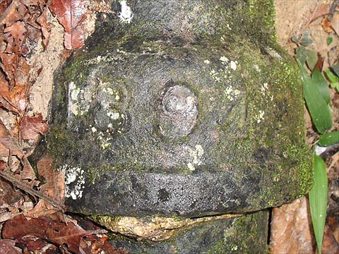
At first it's a well defined path, although the big pipe has vanished underground, there is a smaller older pipe here, it appears to be inscribed 1894. It runs to a very small dam which marks the end of the path proper.
I had rather hoped there would be a trail to the col, but there was no obvious route ahead. However, slightly to the right there was a trail upwards with a very distinctive mark. The local hash must be turning soft because there were small ropes on many of the steeper sections:
It was the kind of trail which I would almost have run up nearly 40 years ago, but now I set a more sedate pace and after a while I came to a flat clearing which was a jungle crossroads. Right and straight on would have gone back down no doubt to some part of Tanjung Bunga so I struck off left and continued my climb. Since my days of the 'one size fits all' hash, all sorts of splinter groups seem to have sprung up, the Tuesday group had been up here less than a week before and some considerable time earlier, maybe another group, although it might simply have been a case of recycling. When I got to the true summit I found a small metal enclosure which I am sure had held a rain gauge at one stage, come to think of it, maybe it's still there under the ferns.
I was pretty certain that this was the top of the hill immediately above our home in Seaview Garden and I was very conscious that when I had come up that way I had turned right too early on my descent and had ended up in an abandoned development behind Moonlight Bay. So this time I consciously stuck to the ridge that that ran away from the back of the rain gauge and away from the sea. It was a little overgrown but there were more of the PH4 papers and a new trail marker. About half way down, there was a tempting ridge on the left but on checking there was no obvious trail along it. I continued down and eventually the terracing became typical of an abandoned rubber estate which made for slower progress. Finally, I came out into an area which had been cleared in the not too distant past and found signs of a pipeline. Once it appeared above the surface, there was just one problem, it ran almost vertically down the hill to what I could see was the Batu Ferringhi Aqueduct at the bottom. It took quite a while to get down - that's the view looking back up!
Should I have been in any doubt as to where I had ended up, someone had put up a convenient notice for me:
After that it was just a pleasant stroll down to the main coast road and a 101 bus home.
|